|
a free and open toolkit for 2d/3d seismic data analysis |
|
kogeo seismic toolkit |


|
Contact:
|
|
Phone (home): +49 - 40 - 2780 7890 Phone (office): +49 - 40 - 42838 5234 Fax: +49 - 40 - 42838 7081 E-Mail: konerding@geowiss.uni-hamburg.de |
|
Features |
|
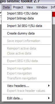
The navigation tools within kogeo are located in the ‘Data’ menu:
Navigation data can be imported from trace headers or from tables in external files; especially when working with project databases, specification of line navigation is obligatory.
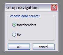
Navigation import: In order to specify navigation data for the currently active data in your kogeo session, use the ‘Import navigation’ menu item. First you’ll be prompted to choose a source to import from:
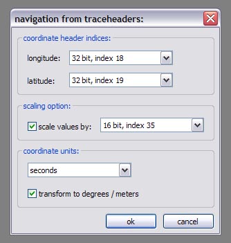
1. Import from trace headers: The trace header import dialog will appear:
In the upper part of the dialog window header indices to retrieve x and y values for the individual traces must be set. These (raw) values might be scaled according to the SEG-Y rev. 1 standard when the ‘scale values by’ option is activated (see the SEG-Y format description on www.seg.org for more details); the respective scaling factors will be read from the specified header index. A coordinate unit must be set in the lower part of the dialog window, if it’s not meters or degrees, the imported navigation might be automatically transformed to meters (from metric units) or degrees (from angles) when the corresponding option is activated. The navigation values are imported and scaled trace by trace; no interpolation is performed.
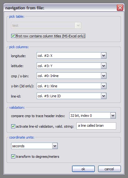
2. Import from file: After you’ve specified a file (can be in .dbf, .xls or .mdb format) to import the navigation data from, the ‘navigation from file’ dialog will appear:
If the import file contains more than one table, select the right one in the ‘pick table’ section of the dialog window, if the import source is a MS-Excel file, activate the ‘first row contains column titles’ option if necessary. Navigation values are imported according to the columns specified in the ‘pick columns’ section. In order to attach them to seismic traces, they are validated by comparing them to cmp numbers read from the trace headers (the corresponding header index can be specified in the ‘validation’ section). An additional validation by comparing line-id strings can be requested if the according option is activated; this is necessary if the file to import navigation from contains data for more than one seismic line. The ‘coordinate unit’ section works in the same way like described in 1. During the import process entries from the import table are read and attached to corresponding cmp numbers. Afterwards values for missing cmp’s are linearly interpolated/extrapolated to set up the complete line navigation.
Navigation transformation: After the navigation for a seismic line is imported, you can use the navigation transform function to project, un-project or re-project it. The following map projection methods are available within the navigation transform function: · Mercator · Transverse Mercator · Lambert Conformal Conic · Azimuthal equidistant · Lambert azimuthal equal area · Polyconic · Van der Grinten I · Stereographic · Miller cylindrical · Sinusoidal
For datum definitions the following spheroids are defined:
· Airy 1830 · Australian national 1865 · Bessel 1841 · Clarke 1866 · Clarke 1880 · Everest 1830 · GRS 1980 · International 1909 · Krasovsky 1949 · Sphere (r=6.370.997 m) · WGS 1972 · WGS 1984
The ‘Transform navigation’ menu item is available only if line navigation is imported; the function’s parameters are set in the corresponding dialog:
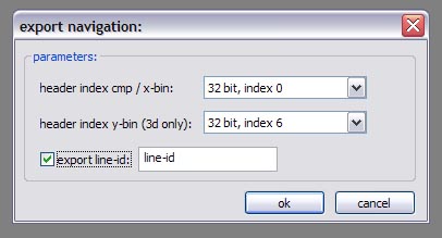
On the left side of the dialog window, the actual coordinate settings must be given, on the right specify the transformation target. The transformation process itself comprises the following steps: First the data is un-projected, if necessary. Afterwards, the data is transformed from longitude, latitude values to earth-centered/earth-fixed coordinates (x, y, z). These coordinates can shifted and rotated to match a local datum according to the settings of the datum shift options using a 7 parameter helmert transform. The resulting x, y, z coordinates are transformed back to longitude, latitude and in the end projected again, if this is requested. Navigation export: Line navigation values can be exported to a .dbf table or an .xls spreadsheet using the ‘Export navigation’ menu item. After you’ve specified a file to export the coordinates to, the ‘export navigation’ dialog window will appear:
Navigation values will be exported along cmp values (2d data) or inline, crossline values (3d SEG-Y data) taken from trace headers - inline, crossline numbers specified during the import of the data are only exported in 3d project mode; this will be changed soon. Additionally you can specify a line-id string that will be also written to the exported table. |
Read more about... |
|
...navigation tools |

|
You‘re visitor no.: |
|
Home |
|
About kogeo |
|
Features |
|
Download |
|
Building instructions |
|
Guestbook |

|
Home |
|
About kogeo |
|
Features |
|
Download |
|
Building instructions |
|
Guestbook |